Trail Guide
Virtual Watershed Interpretive Trail
Open to the public for self-guided exploration, hours vary by season. A schedule of monthly activities are show on our calendar. Tours and educational programs for groups provided upon request. For more information, please call: 503.632.2150.

The Watershed Interpretive Trail is designed to introduce you to some important ideas about watersheds and woodland resource management. Along the trail you’ll find numbered signs that correspond to descriptions found in this brochure. To get the most out of the trail, stop at each signpost, read the entire description, and look carefully at the features that are described. Note that there are two major trail loops. Different features are highlighted in each loop, so both are recommended. The time needed to hike both loops, stop, read and view the various features, is about 2 hours.
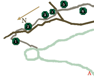
East Loop
What’s a watershed? It’s an area of land that collects rain and snow and discharges much of it to a stream, river, or Other water body. The specific water body of concern is what defines a watershed.
Most of the watershed for the stream at this point is land owned by neighbors upstream (about 500 acres). What happens on this neighboring land can affect the quality and quantity of water that flows here. Likewise, activities on the Hopkins Memorial Tree Farm can affect water that flows through properties downstream on its way to the Molalla River and beyond. Watersheds can thus link landowners and others in important ways, which points to a “good neighbor” approach to resource management.
Nature itself can be an important influence on watershed resources. Notice the beaver pond upstream. Flooding and slow drainage from such ponds can kill trees and other shading vegetation and raise water temperatures. Beaver may also contaminate water supplies with diseases like Giardia. On the other hand, new types of fish and wildlife habitat have been created by the pond, and it may also act as an effective sediment trap. Environmental change is common in nature. Carefully observing such change helps us keep human activities in perspective.
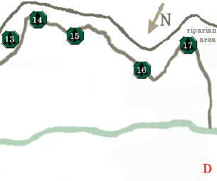
You’re now standing in a riparian zone, the area of moist soils and related plant cover next to a stream or other water body. These areas often have important functions and values. Riparian trees or smaller plants can provide shade that helps keep stream temperatures cool. Wildlife may find abundant food and cover here. Trees and other large woody debris that fall into streams can create valuable pools for fish, and leaves from riparian plants provide food for insects that fish eat. Timber, forage, and recreational valuesalso may be high. Because of such values and the potential for affecting water and other resources, Oregon’s Forest Practice Rules (Administered by the Oregon Department of Forestry) often require forest landowners to modify their management practices in riparian zones.
Along this Watershed Interpretive Trail you will notice white fiberglass rods marking the riparian management area. Markers are located 20 feet and 50 feet from the high water level of the stream channel. In Oregon, no vegetation within the first 20 feet of a stream – having the same size as the one here at Hopkins – can be disturbed. Between 20 and 50 feet from the stream, some management including limited tree removal, may be allowed. All roads must be located more than 50 feet from streams of this size.
On the other side of the stream you’ll notice a large, old stump. Look carefully and you can see a rectangular “spring – board hole” in the stump. The old stumps you’ll find along the trail show there was logging in this area several decades ago. This and other historical activity (e.g. farming, road building) no doubt had some effect on the riparian zone and seam channel seen here today. Keep in mind that technology and legal requirements were limited prior to the 1970’s. Also, for a number of years, large woody debris was removed from stream channels in this region to help fish move upstream to spawn. Today, we recognize that this practice probably harmed fish habitat, and our knowledge of how to protect and enhance such watershed resources has improved greatly.
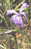
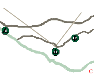
The stream meanders quite a bit here, showing channels are dynamic and often have areas of natural erosion and deposition that can shift over time. In most cases, it’s best not to try to control these natural processes, unless property or other resources are threatened. Even then, special expertise usually is needed. Note that the roots of the cedar tree are helping to protect and stabilize the bank at the big bend of the stream.
Another 50 feet or so farther along, next to the trail, is a large cedar snag, or standing dead nee. Snags often are important habitat for “cavity nesting” birds and other wildlife that can be abundant in riparian areas. Eventually, they may provide large woody debris to stream channels. Cedar and other conifer snags and debris are particularly valuable to wildlife and fish because of their size and slow decay.
Several logs cross the stream here but don’t affect the channel very much, except to provide a bit of cover. With time they will break up and fall into the stream, probably forming some pools. The moss and other plants on these logs show that over the years since they fell, the water level rarely reaches the tops of the logs. Such clues can help us estimate what this stream looks like during major storms, which is helpful when planning stream crossings or other activities near the channel.
You just crossed a small tributary that feeds into the main channel. Such streams may have only intermittent flows instead of carrying water throughout the year (i.e., perennial), and they often do not show up on maps. They can still influence the quality and quantity of the waters they feed into, so they shouldn’t be ignored when planning management activities. This is especially important because many activities are done during the dry season, when a lack of water often make smaller tributaries hard to identify.
Notice the variable tree cover. Riparian areas usually have plenty of moisture and fertile soil for trees and other plants to grow well, but this can also create a lot of competition for space and light. If seedlings of trees like Douglas – fir that need direct sunlight were planted here for habitat or timber, they probably would not survive unless the competing vegetation was controlled in some way. Even seedlings of cedar or hemlock that can grow in shade may not survive, or they may take many years to outgrow the competition.
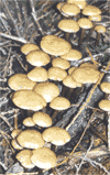
Note the large fire scarred stump on the right side of the main trail that now follows an old road. Natural wildfires and prescribed burning for logging debris disposal or reforestation (by eliminating competing plants) have occurred throughout this region. When fires are hot enough to consume the duff layer (leaves, needles, twigs, etc.) that normally covers the soil, runoff and erosion may increase from sloping areas. Wildfire hazards can be reduced by using fire breaks (i.e., roads and other areas with little fuel) and by maintaining good access and a reliable supply of water (in addition to the stream, there are two ponds near the middle of this property). Prescribed burning can be scheduled during cooler or wetter periods to reduce the loss of protective duff, and areas near the streams or in very steep terrain can be left unburned.
Looking just a bit farther to the side of the trail opposite the stump, you may see a dirt bike trail that enters from the left. Unauthorized recreation sometimes causes soil and water problems. Sturdy gates can limit access by 4 – wheelers, but those on foot, horseback, or two – wheels (motorized or not!) can be difficult to control. Keep in mind that such problems may be unintentional, and visitors may simply need to know what you’d like them to do or not do. Signs or direct contact may be helpful.
Although this road was constructed many years ago, it follows a good layout. Even though it generally runs parallel to the stream, it is located well away from the channel and riparian area. Up ahead, where the road crosses the stream, it does so at a right angle (i.e., perpendicular to the seam). This keeps stream and riparian disturbance to a minimum, and reduces the chance of any runoff or sediment from the road getting into the stream.

Landowners who plan to build roads that cross streams may need to get help to comply with the law and avoid watershed impacts. Local offices of the Cooperative Extension Service and the Oregon Department of Forestry are among the sources of assistance. Detailed information about the vented ford, it’s design, installation and cost, contact Forests Forever, Inc. or the OSU Extension Office in Oregon City.
Although this road was constructed many years ago, it follows a good layout. Even though it generally runs parallel to the stream, it is located well away from the channel and riparian area. Up ahead, where the road crosses the stream, it does so at a right angle (i.e., perpendicular to the seam). This keeps stream and riparian disturbance to a minimum, and reduces the chance of any runoff or sediment from the road getting into the stream.

Between Loops
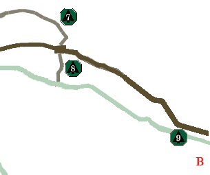
If you now head west on Up Creek Road (left), you’ll soon reach the “Middle Loop” of the Watershed Trail. Along the way, be sure and see Stops 9 and 10. If you’re short of time, you can turn right (east) and return to the main road (Grouse Hollow) via Carlson Road, which connects with the start of the Watershed Trail.
Keep in mind that even with the best road and crossing designs, upkeep will be needed to maintain good drainage and avoid erosion. For example, culverts should be inspected regularly for blockages or other problems. Grading (i.e., scraping and shaping the road surface) and ditch cleaning can help eliminate ruts and restore good drainage. Wet weather is an especially important time to inspect roads and to correct problems quickly before they cause damage or become much more difficult to handle.

Because this road was constructed many years ago, its location near the seam is less than ideal. Upgrading the drainage system and running surface was begun recently along this road so that vehicle traffic will not add excess runoff and sediment to the stream. The new ditch on the uphill side of the road collects drainage water from the road and hillside. This water travels through plastic culverts under the road, like the one located here. The discharge water splashes against rocks placed at the outlet end of the culvert to slow its movement and settle sediment before reaching the stream. When – ever possible, water draining from forest roads should be routed to undisturbed areas to settle sediment. Another option is to construct a small settling basin to trap sediment from the road. Finally, roadside areas have been seeded with annual rye grass to protect the sop and prevent erosion. Seeding is usually most effective in western Oregon when done in the late summer and early fall.
Middle Loop
The trail has been routed upslope around a property boundary. A comer of the neighboring property extends to this side of the stream. A new stream crossing might be needed if the neighbor wanted access to cut some timber or for other purposes. Because of the cost and possible resource impacts of new stream crossings, it might be better to talk to the neighbor about a reciprocal access agreement. Landowners can thus arrange a way to use each other’s roads to access their property on both sides of the stream.
Neighboring landowners can make other arrangements to their mutual benefit. Contractors who do road maintenance (grading, ditch cleaning, etc.) may provide a price break when adjacent work avoids costs of moving heavy equipment. Likewise, the cost of culverts, rock surfacing, tree seedlings, chemicals, etc. may be less if a larger order is arranged among landowners. Talk with your neighbors; you may find you’re thinking about doing some similar work. You might also be able to share valuable experience and ideas about woodland and watershed management, and perhaps work together to benefit both the watershed and you.
Notice the well – stocked red alder stand on the terrace near the stream. In some areas, riparian alder stands can affect water quality when leaves are shed in the fall. This is most likely on small streams when fall rains come late. Leaves mix with slow – moving water to form a “tea” rich in organic matter. This can be a problem for aquatic life if oxygen levels become low, and it can make water distasteful or unhealthy to drink. A strategy to convert riparian alder stands to conifers may be desirable where such water quality problems occur often. However, special riparian management plans must be approved before any harvesting, site preparation or reforestation activities can occur within 50 feet of this stream channel.
Notice the larger conifers on the other side of the stream. Some, near the stream, will need to be retained for fish and wildlife habitat under Oregon’s Forest Practices Rules. If other trees are harvested across the stream, it may be difficult and costly to construct a stable crossing here in this wet, soft soil. As mentioned, it may be best to arrange an access agreement with the neighboring landowner, or else use a crossing in a less sensitive location.

The moisture – loving alder tree is able to grow directly in the channel. It has even formed a pool with its roots that is helping trap sediment. When this tree dies, it will add more structure to the channel, although it will decay more quickly than the nearby cedar logs. Note, too, how a large cedar log has fallen down the opposite slope. Where such steep slopes border a stream channel, woody debris may be supplied by trees quite a distance upslope.
Upslope is another area where trees are generally absent. Cost – share funds may be available to help landowners with reforestation or other watershed improvements. Local offices of the Oregon Department of Forestry and the Clackamas County Soil and Water Conservation District can provide details and assistance.
End of the Trail
Think about the many features and contrasts in the stream and riparian area that you have seen along this trail. Even over a short distance, conditions and management considerations can change dramatically. This can make watershed management very challenging. It also offers a fascinating area for work and study exploring the vital links among natural resources and people.
The end of the Watershed Interpretive Trail doesn’t mean you can’t learn more about watersheds and resource management. Many publications, audio – visual programs, and other resources are available. In addition, educational programs and tours are held often by the Cooperative Extension Service, local chapters of the Oregon Small Woodlands Association, and other groups.
Watch for notices about future educational activities at the Hopkins Memorial Tree Farm. Detailed information – including this brochure
Neighboring landowners can make other arrangements to their mutual benefit. Contractors who do road maintenance (grading, ditch cleaning, etc.) may provide a price break when adjacent work avoids costs of moving heavy equipment. Likewise, the cost of culverts, rock surfacing, tree seedlings, chemicals, etc. may be less if a larger order is arranged among landowners. Talk with your neighbors; you may find you’re thinking about doing some similar work. You might also be able to share valuable experience and ideas about woodland and watershed management, and perhaps work together to benefit both the watershed and you.
Acknowledgements
This trail and brochure were made possible by support from the Governor’s Watershed Enhancement Board (GWEB) with funds from: the Oregon State Lottery, Clackamas Soil and Water Conservation District, Forests Forever, Inc., the Stewardship Incentive Program and the Oregon State University Forestry Extension Program. Special thanks go to Liz Dent, John Poppino, Gilbert Shibley, Abigail Romick, Ken Humbert, Terry Wertz and Aaron Bondi for their help in stream and watershed inventory, trail layout and brochure preparation. Paul Adams, OSU’s Forest Watershed Extension Specialist, and Mike Bondi, OSU’s Extension Forestry Agent in Clackamas County, directed the project and authored this brochure. For more information or to arrange educational activities at the Hopkins Memorial Tree Farm, contact the OSU Extension Office in Oregon City 503.655.8631.
